¶ Description hierarchy
|
|
<LandXML> | Transfer file | ||||||
|
|
<Units><Metric> | Units (Metric) | ||||||
|
|
<CoordinateSystem> | Coordinate and elevation systems | ||||||
|
|
<Start> | Base point | ||||||
|
|
<Project> | Project | ||||||
|
|
<Feature> | "IM_codings" extension type coding systems |
||||||
|
|
<Application> | Application | ||||||
|
|
<Author> | Authors | ||||||
|
|
<Surfaces> | Surface group | ||||||
|
|
<Surface> | Surface | ||||||
|
|
<SourceData> | Source data | ||||||
|
|
<Breaklines> | Breaklines | ||||||
|
|
<Breakline> | Breakline | ||||||
|
<PointList3D> |
3D point list | |||||||
|
<Feature> |
"IM_coding" extension type coding Breakline |
|||||||
|
|
<DataPoints> | Random points | ||||||
|
|
<PntList3D> | 3D point list | ||||||
|
|
<Feature> | "IM_coding" extension type coding Random points |
||||||
|
|
<Definition> | Surface description | ||||||
|
|
<Pnts> | Vertices | ||||||
|
|
<P> | Vertex | ||||||
|
|
<Faces> | Triangle mesh | ||||||
|
|
<F> | Face | ||||||
|
|
<Feature> | "IM_coding" extension type coding Surface |
||||||
|
|
<Feature> | "IM_plan" extension plan information |
||||||
|
|
<FeatureDictionary> | extension definitions |
||||||
¶ 7.1 Contents
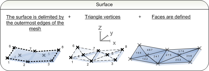
Area structures encompass descriptions of surfaces that complement routes. Such surfaces are e.g. landscaping, noise barriers and geostructures. The file in which these structures are described contains the header information presented in chapter 1. Area structures are described as surfaces <Surface> in inframodel compliant file transfers. These surfaces consist of triangular meshes. It is also possible to attach random points <DataPoints> and breaklines <BreakLines> to the surfaces. Area structures are described in the same file as the route they are built in conjunction with, e.g. a noise barrier is in the same file as the railway it is built for.
¶ 7.2 Landscaping
Landscaping encompasses the areas surrounding a design entity. The description consists of a surface description, which is described in further detail in section 2.4. The surface description consists of a triangle mesh, which may have random points or breaklines attached to it. Structural surfaces or cross-sections are usually not defined for landscaping.
The landscaping plan information is defined in the optional extension "IM_plan". A surface code (SurfaceCoding) is set for the surfaces . It is also possible to set an alternative type coding (proprietaryInfraCoding).
Contents of landscaping:
surface model
structural model
Optional surface information
breaklines <BreakLines>
|
|
Surface model | short example |
|
|
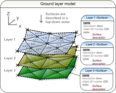
Ground layer model | short example |
¶ 7.3 Noise barriers
Noise barriers are a central part of route planing. The process of describing the components is described in detail in section 2.4. The The surface description consists of a triangle mesh, which may have random points or breaklines attached to it. Structural surfaces or cross-sections are usually not defined for noise barriers.
The noise barrier plan information is defined in the optional extension "IM_plan". A surface code (SurfaceCoding) is set for the surfaces . It is also possible to set an alternative type coding (proprietaryInfraCoding).
Contents of noise barrier:
surface model
structural model
Optional surface information
breaklines <BreakLines>
|
|
Surface model | short example |
|
|
Ground layer model | short example |
¶ 7.4 Geostructures
Geostructures in inframodel compliant file transfers refers to area-like structures that can be easily described in terms of surfaces. Examples include stacking of excess mass and subgrade reinforcement, which are possible to describe as surfaces such as described in section 2.5.
The process of describing the components is described in detail in section 2.4. The The surface description consists of a triangle mesh, which may have random points or breaklines attached to it. Structural surfaces or cross-sections are usually not defined for geostructures.
The geostructure plan information is defined in the optional extension "IM_plan". A surface code (SurfaceCoding) is set for the surfaces . It is also possible to set an alternative type coding (proprietaryInfraCoding).
Contents of geostructures:
surface model
structural model
Optional surface information
breaklines <BreakLines>
|
|
Surface model | short example |
|
|
Ground layer model | short example |